
Mount Shasta
HOTLUM
CONE
(post 9500 yrs)
SHASTINA
CONE
(9700-9500 yrs)
( RED FIR CONE )
MISERY HILL CONE
(50,000-30,000 yrs)
SARGENTS RIDGE
CONE
(200,000-100,000 yrs)
THE FOUR MAJOR CONES OF MOUNT SHASTA
INTRODUCTION
Travelers have been coming to the Mount
Shasta region in northern California since the 1820’s. Nearly everyone who sees
Mount Shasta for the first time is struck by the beauty and majesty of this solitary
snow-capped mountain surrounded by a multitude of natural wonders. The Mount
Shasta Fact Sheet was developed to answer many of the common questions
visitors have about the mountain and the area. It is also meant to provide a
glimpse into the rich history of Mount Shasta. The Fact Sheet is written by William
Miesse, author of Mount Shasta: An Annotated Bibliography [MS2030], a
guide to the extensive resources of the College of the Siskiyous Library’s Mount
Shasta Collection. It is impossible to answer all of the questions people may have,
so I invite you to explore the resources of the Mount Shasta Collection and to
contact us for more information. Corrections and suggestions for the Fact Sheet
are welcome.
-Dennis Freeman, Library Director, College of the Siskiyous
ˈ Geologic and Geographic Descriptions
ˈ Native Americans
ˈ Origin of the Name “Shasta”
ˈ Timeline of Historical Events
ˈ Lemurians and Metaphysical Legends
ˈ Famous Writers, Artists, Photographers
ˈ Place-Names History
ˈ Little-Known Facts About Mount Shasta
Fact Sheet
Location Siskiyou County, California. The mountain is about 60 miles south of
the California-Oregon border and about 60 miles north of Redding, California.
Latitude 41.42 North / Longitude 122.20 West
Elevation of main Shasta peak 14,161 feet (4,317 meters).
Elevation of lesser Shastina peak 12,330 feet (3,758 meters).
2nd highest volcano in Cascade Range, after Mt. Rainier. 4th highest volcano
in N. America. 5th highest mountain in Calif.; 61st highest in N. America.[MS3044]
Timberline at 8,000 - 8,500 feet (2,400-2,600 meters) around the mountain.
Diameter of base ~16 miles (27km). Circumference ~50 miles (84km).
Volume 120 cubic miles (500 cubic km). Largest Cascade stratovolcano,
bigger in volume than Mount Rainier.
Glaciers Seven USGS officially named glaciers- Bolam, Hotlum, Konwakiton,
Wintun, Mud Creek, Watkins, Whitney. Indian names from John Wesley Powell,
who climbed Shasta in 1879; Whitney glacier named by Clarence King in 1870.
Three small additional glaciers have been proposed: Upper Wintun, Chicago,
and Olberman. [MS433, MS3015, MS2151]
Watershed Underground flow through the fragmented lavas of Mount Shasta
creates many pure springs; two “Big Springs,” one in the Mount Shasta City
Park and another in the Shasta Valley, are often considered the main sources
of the Sacramento and Shasta Rivers. International bottling companies includ-
ing Crystal Geyser, Danone (Coca-Cola), and Nestle currently bottle or have
water bottling rights for Mount Shasta spring waters.
Waterfalls The Whitney, Coquette, Ash Creek, and Mud Creek falls. [MS433]
Hot Springs Two separate small sulfurous hot spring areas near main summit,
temperatures have varied over the years from 150 to 183 degrees F. [MS416, MS199]
Cascade Range The Cascade Range consists of the active High Cas-
cades and the parallel older inactive Western Cascades. The High Cascades
range from Mt. Garabaldi (40 miles north of Vancouver, British Columbia)
south to Lassen Peak in northern California. The vulcanism in the High Cas-
cades is caused by the subduction of the Explorer, Juan De Fuca, and Gorda
oceanic tectonic plates sliding beneath the North American plate. The melted
materials then rise and erupt. There are about 20 major volcanic peaks in the
High Cascades range, and hundreds of smaller volcanic structures. [MS2151]
Ring of Fire The Cascades are part of the ‘Ring of Fire,’ a chain of volcanic
arcs and oceanic trenches found at tectonic plate borders around the Pacific Basin.
Shasta Valley Hills The hills in the Shasta Valley are mostly debris from
the massive collapse of the Ancestral Mt. Shasta sometime between 360,000 and
160,000 years ago; geologists consider it one of the largest landslides on earth. [MS426]
“I consider the evening twilight on Mt. Shasta one of the grandest sights I have ever witnessed.”
~President Theodore Roosevelt, 1908. [MS1032]
© 2005 College of the Siskiyous Library 06-21-05
Page 1
Inquiries College of the Siskiyous Library, 800 College Ave., Weed, CA 96094.
Phone: (530) 938-5331 E-mail: library@siskiyous.edu Fact Sheet web page
with references at: http://www.siskiyous.edu/library/shasta/factsheet/
GEOLOGIC DESCRIPTION
A Compound Strato-
volcano. Although it looks like just two volcanic cones, Mt. Shasta is actually
composed of four major volcanic cones. Each cone is built of layers, or strata,
so each cone is itself a stratovolcano. Each cone was created in its own eruptive
period. Mt. Shasta is called a compound stratovolcano because the four separate
stratovolcanic cones are overlapping. Portions of the summit craters of all four major
volcanic cones remain. A fifth cone, the Red Fir Cone, named for its rocks which
outcrop at Red Fir Flat at 6340 feet and elsewhere lower on the mountain, was part
of an earlier and since collapsed compound stratovolcano often referred to as the
‘Ancestral Mt. Shasta.’ The oldest rocks on Mt. Shasta, those of the Red Fir Cone,
are about 590,000 years old. Almost all you can see of Mt. Shasta is less than
200,000 years old, and the Shastina cone is only about 9700 years old. The last
eruption was about 200 years ago from the Hotlum cone. [MS2151, MS199]
GEOGRAPHIC DESCRIPTION
part of an ancestral Mt.
Shasta, 590,000 year
old rocks.
REFERENCES,
e.g. [MS2151], may be accessed from the Fact Sheet
web page at http://www.siskiyous.edu/library/shasta/factsheet/
NATIVE AMERICANS
of the Mount Shasta Region
Evidence of an Indian camp on the north side of Mt. Shasta dates back to at least 600
BCE and possibly to 2500 BCE. Artifacts in the greater region suggest 9,000 years
of Native American habitation. Mt. Shasta is a ‘corner’ territorial boundary for four
Native American peoples: The Shasta, Modoc, Ajumawi/Atsuwegi, and Wintu. Addi-
tionally, Mt. Shasta is within the view of the Karuk Tribe on the mid-Klamath River
and the Klamath Tribe of the upper Klamath River. [MS49, MS761, MS1219, MS577, MS2195, MS816].
THE NAME SHASTA
The word ‘Shasta’ is a modern
spelling of the name of a Native American tribe first spelled as “Sastise” in the
Dec. 26, 1826 journal entry of Hudson’s Bay Company fur brigade leader Peter
Skene Ogden. Ogden, while in the Klamath Lakes area, states that the name
“Sastise” was used by the Klamath Indians for an enemy tribe on the oth-
er side of the mountains. Traveling to the other side of the mountains and into
the Rogue River Valley on Feb. 14, 1827 he gave the name “Sastise,” which he
also spelled as “Sasty,” not to present-day Mt. Shasta, but to present-day Mt.
McLoughlin in southern Oregon. Ogden had seen present-day Mt. Shasta earlier
while he was in the Klamath Lake region, but never gave it a name. Through-
out the 1830’s and early 1840’s present-day Mt. McLoughlin remained on maps
named “Sasty” and present-day Mt. Shasta was variously named on maps as “Mt.
Simpson,” “Pit Mountain,” or “Mt. Jackson.” A few explorers beginning with
Alexander R. McLeod in 1830 would confuse which mountain was “Sasty,” as did
the United States Exploring Expedition in 1841. Books and emigrant maps based
on the authoritative surveys of the Exploring Expedition firmly transferred the name
“Sasty,” later spelled “Shasta,” to present-day Mt. Shasta. [MS173, MS654, MS528, MS1154]
ERUPTIONS
When Did Mt. Shasta Last Erupt?
A U.S. Geological Survey report in 1980 states that a pyroclastic flow and hot mudflow
traveled down Ash Creek and another hot mudflow down Mud Creek about 200
years ago, based on radiometric dating. This is the main report citing eruptive
activity of Shasta about 200 years ago (from a 1980 date). An oft-mentioned 1786
sighting of Shasta in eruption, however, is an error. [MS199, MS2151, MS412, MS2198]
Will Mount Shasta Erupt Again? Yes. Mount Shasta is dormant but will
erupt again. Geologists think Shasta has erupted 10 or 11 times in the last 3,400
years, and at least 3 times in the last 750 years. Keeping in mind that statistically
every present year is equal in odds even if an eruption hasn’t happened in 200
years, the odds for an eruption are thought to be as follows:
1 in 250 to 300 in any given year.
1 in 25 to 30 in any given decade.
1 in 3 to 4 during a person’s lifetime.
Recent investigations suggest both Mount St. Helens and Mount Shasta are locat-
ed on the boundries of large rotating blocks of the continental plate itself, which
could explain the higher number of past eruptions of these two peaks versus other
Cascade volcanoes. Nearby Lassen Peak erupted dramatically from 1914 to 1921 with
170 explosive eruptions in the first year alone.[MS141,MS2151,MS199, MS274, MS755]
An Eruption in 1786 : A Misinterpretation Geologists sometimes
accept as fact that in 1786 the famous French explorer Francois Galaup de
LaPerouse saw from his ship off Cape Mendocino an eruption of Mount Shasta.
LaPerouse wrote in his journal that he witnessed a volcanic eruption. However,
the idea that it was Shasta, or even a volcanic eruption, is very doubtful for two
reasons: First because in 1818 another French explorer, Camille De Rocque-
feuil, also sailing past Cape Mendocino, explained that: “The natives, at this
season, set fire to the grass...doubtless, this circumstance, which was
unknown to our illustrious La Peyrouse, and that was the cause of his
error, when seeing a great fire on Cape Mendocino, about the same
time of year, he thought it was a volcano.” Second, and more important,
LaPerouse’s detailed 1786 manuscript map shows he saw an event directly on the
Mendocino coast, and not something further inland. [MS281, MS828, MS2150]
1817 Possible Mt. Shasta mention (as “Jesus Maria”) by Fray Narciso Duran. [MS198]
1821 Possible Mt. Shasta mention (“Los Quates,” ‘twins’) by Louis Arguello. [MS358]
1826 Dec. 26. Mt. Shasta seen but not named, by Peter Skene Ogden. [MS175]
1827 Feb. 14. Name ‘Sasty,’ ‘Sastise’ given to present-day Mt. McLoughlin, by
Ogden. Name transferred in 1841 mistakenly to present-day Mt. Shasta. [MS175]
1828 Jedediah Smith sees Mt. Shasta, names it “Mt. Simpson.” [MS170, MS1036]
1830 Alexander R. McLeod snowbound, loses 300 horses, 2400 furs. [MS651]
1837 Ewing Young and Philip L. Edwards lead cattle drive up Sacramento
canyon, 630 of 729 cattle complete arduous journey to Oregon. [MS2, MS332]
1839 Hall J. Kelley names Mt. Shasta “Mt. Jackson,” part of President’s Range.[MS17]
1841 U.S. Exploring Expedition, aka Wilkes Expedition. First scientists at Mt. Shasta,
officially transfer ‘Shasta’ name (spelled ‘Shasty’) to the California mountain [MS672]
1850 W. S. Lowden party, first recorded summit attempt, turns back. [MS67]
1852 John Jeffrey discovers ‘Jeffrey’ pine, climbs to Mt. Shasta’s timberline. [MS791]
1854 Elias Davidson Pierce and party, 1st ascent of Mt. Shasta summit. [MS 599]
1854 Joaquin Miller, author, begins four year stay in Mt. Shasta region. [MS215]
1855 Israel S. Diehl, first solo ascent of Mt. Shasta. Mentions seeing glaciers .[MS557]
1856 Harriette C. Eddy and party, first ascent of Mt. Shasta by women. [MS1279]
1862 California Geological Survey, J. D. Whitney and William Henry Brewer climb
Mt. Shasta, 1864 survey return trip includes Clarence King. [MS224, MS625]
1868 Justin H. Sisson, guide and innkeeper, places register on summit,
where it remained until 1900. Signed by Muir, King, Powell, etc. [MS505]
1870 Clarence King discovers first active glaciers in U.S. on Mt. Shasta. [MS223, MS231]
1873 Joaquin Miller’s popular Life Amongst the Modocs makes Mt. Shasta well-
known, the Modoc War of 1873 also puts Mt. Shasta in the public eye. [MS806]
1875 John Muir, famous overnight survival in snowstorm on summit. [MS10]
1875 Reflecting signal cone built on summit for U.S. Coast and Geodectic Survey
triangulation, tower falls 1903 (cone now at Sisson Museum.) [MS54, MS530]
1877 Asa Gray, Joseph Hooker, famed botanists, visit Mt. Shasta with Muir. [MS3036]
1879 USGS director John Wesley Powell climbs Mt. Shasta. [MS732]
1879 World record: mirror flashing, 192 miles, Mt. Shasta to Mt. St. Helena. [MS530]
1887 Railroad last spike driven in Ashland, Oregon, connects Oregon and
California, boom in population, settlement, lumbering, and tourism. [MS1177]
1888 National Park proposals for Mt. Shasta by railroad and others. [MS116]
1898 U. S. Biological Survey of Mt. Shasta, led by C. Hart Merriam. [MS169]
1905 Shasta National Forest established by Theodore Roosevelt. [MS3035]
1923 Dedication of Sierra Club’s Shasta Alpine Lodge at Horse Camp. [MS1121]
1924 Konwakaton Glacier creates dam, releases massive 7 million cubic yard
mudflow; frontpage news in S.F. papers for weeks, McCloud threatened. [MS2078]
1959 Mount Shasta Ski Bowl opens. Closes in 1978 after avalanche. [MS3025]
1984 California Wilderness Act of 1984, 37,000 acres of the Shasta-Trinity
N.F. on Mt. Shasta are designated as the “Mount Shasta Wilderness.” [MS1076]
1985 Mount Shasta Ski Park opens on Douglas Butte volcanic cone. [MS3026]
1985 Robert Webb, record climb, Horse Camp to summit, 1 hr. 39 min.
(the average climber’s time is about 8 hours). [MS457]
1987 Harmonic Convergence, Shasta one of many world power point sites. [MS143]
1994 Keeper of the National Register of Historic Places designates Panther
Meadows and Mt. Shasta above 8,000 feet as a historic district. [MS2091]
1995 Large six-fingered avalanche on west side of Shastina alters landscape,
still visible from freeway just north of Mount Shasta City. [MS2092]
1997 Whitney Creek debris flow cuts off half mile of Highway 97, burying
highway to depth of 4-5 feet. [MS2152]
2002 Four parapalegic climbers, 3 men and a woman, each using hand-
cranked ‘snow pods,’ achieve summit after several epic days of work. [MS3011]
Page 2
TIMELINE OF HISTORICAL EVENTS
Little-Known Fact Prior to 1850 spellings for the mountain included Sasty,
Saste, Shasty, Shasté, Shaste, Shastl, Tshastl, Chasta, Chaste, Chasti, and Chastl.
In 1850 the California State Legislature officially adopted the name and spelling of
SHASTA for the new Shasta County and for the mountain itself. Surprisingly, this
is the first time the spelling “Shasta,” with both an intial “S” and a last letter “A” is
used in print. It is likely that Spanish maps of early California were consulted for
new county names. Spanish place names commonly ended in “a” or “o” to indicate
gender, and the county name of “Shasta” was probably spelled to conform to this
pattern. Siskiyou County was carved out of Shasta County in 1852. [MS1154, MS3039]
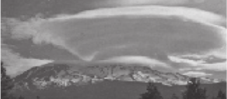
Clouds: Mount Shasta is known for its
spectacular lenticular clouds, especially in Fall
and Spring. They appear stationary, but are
actually continuously forming from multiple
flowing horizontal layers of condensation.
Creation and Other Stories All the tribes noted above revered
Mount Shasta and have myths recorded about the creation of the mountain
or feature Shasta in a teaching myth. ‘The Great Spirit Builds Mount Shasta
To See The Ocean’ tells of the creation of the mountain itself and of
the hillocks in Shasta Valley. ‘The Great Spirit With The Mountain As His
Wigwam, His Daughter, And The Grizzlies’ tells of the origins of the native
peoples. ‘Mis Misa’ tells of the tiny but powerful spirit in the mountain which
balances earth and universe. ‘The Yellowjackets Steal Coyote’s Salmon’
tells how persistence is valued and how the buried salmon high on Shasta
makes one a bit nauseous up there. ‘How The First Rainbow Was Made’
tells of cooperation of animals on the mountain. Many authentic and unusual
teaching stories from Wintu elder Grant Towendolly (Indian name Laktcharar
Tauhindauli) were compiled into the 1966 book Bag of Bones. [MS1102, MS2195,
MS771, MS186, MS2009, MS816]
Writers: Bram Stoker, author of Dracula, wrote the 1895 novel The
Shoulder of Shasta. Robert Heinlein, author of Stranger in a Strange
Land, wrote the 1940 Mt. Shasta story “Lost Legacy.” Joaquin Miller, the
Poet of the Sierras, successful novelist, playwright, and journalist, wrote many
Shasta pieces, including the classic 1873 Mount Shasta novel Life Among
the Modocs: Unwritten History, and the 1881 novel Shadows of Shasta.
John Muir, a great voice for Mount Shasta studies and preservation, wrote the
epic 1875 summit survival story “Snow Storm on Mount Shasta,” and many
other Shasta pieces. John Rollin Ridge, a Cherokee Indian, N.Calif. miner, and
editor for the Sacramento Bee, wrote the highly popular long poem “Mount
Shasta” in 1854. [MS156, MS21, MS212, MS205, MS806, MS215, MS10, MS164, MS219, MS544, MS2192]
“As Lone as God, and white as a winter moon,
Mount Shasta starts up sudden and solitary
from the heart of the great black forests of
Northern California...”~Joaquin Miller, 1874. (First American edition)[MS806]
“When I first caught sight of it [Mount Shasta]
over the braided folds of the Sacramento Valley,
I was fifty miles away and afoot, alone and
weary. Yet all my blood turned to wine, and I
have not been weary since.” ~ John Muir, 1874. [MS176]
LEGENDS OF THE SPIRITUAL MOUNTAIN
The Mystic Temple inside Mount Shasta From 1883 to 1886,
teenage author Frederick Spencer Oliver, while living in Yreka, California wrote the
spiritual fiction novel A Dweller on Two Planets: or, A Dividing of the Way.
In part about Mt. Shasta, it is a source of legends such as Mt. Shasta’s mystical
brotherhood, the mystic temple inside the mountain, mysterious lights, a secret
tunnel entrance, space ships coming out of the mountain, and the ‘I AM’ spirit.
Oliver claimed to be an amanuensis for the ‘true’ author of the book, a non-corporal
entity named ‘Phylos the Thibetan.’ Oliver passed away in 1899 at the age of 33,
the book unpublished. In 1905 Oliver’s mother and a group of friends published the
novel which continues to inspire readers with the mysteries of Mt. Shasta. [MS157]
Lemurians and Mount Shasta The myth of a spiritually advanced
race of people from the lost continent of Lemuria can be traced to the 19th
century writings of H.P. Blavatsky, founder of the Theosophical Society. In 1925
the writer ‘Selvius’ published the first article linking Lemurians to Mt. Shasta. In
1931, Wishar Spenle Cerve (pseudonym of Harvey Spencer Lewis) wrote and pub-
lished Lemuria, The Lost Continent of the Pacific: The Mystery People of
Mount Shasta. Cerve wrote that Lemurians were tall, graceful and agile, with larger
heads and much larger foreheads than average humans. Lemurians would come to
town and spend gold nuggets. The publication of this popular AMORC Rosecrucian
book resulted in a steady stream of writers and tourists coming to Mt. Shasta in the
1930’s and later. (Lemuria was named for the lemur. The name Lemuria was proposed
in 1864 by zoologist Philip L. Sclater for a hypothetical sunken continent which could
account for the migration of lemurs between existing continents.) [MS611, MS153, MS158]
Saint Germain and the Ascended Masters In 1934 Guy
Warren Ballard, using the pen name of Godfre Ray King, published the autobio-
graphical novel Unveiled Mysteries which reveals his 1930 meeting with the
timeless Ascended Master “Saint Germain” on the slopes of Shasta. The book
told about the mountain, and discusses the teachings of the mystic spiritual
teacher Saint Germain and other Ascended Masters who exist on a higher realm.
Ballard explained that Saint Germain was “the same Great Masterful ‘Presence’
who worked at the Court of France previous to and during the French Revolu-
tion...” Mr. Ballard wrote several other books before passing in 1940. His wife Edna
continued the “I AM religious activity” and published many volumes of additional
Saint Germain material. By the 1940’s hundreds of thousands of people were part
of the activity. This religious group, still popular throughout the world, brings many
visitors to Mt. Shasta each summer to attend a series of pageants at the Saint
Germain Amphitheatre in Mount Shasta City. [[MS152, MS913, MS1285]
Artists Well-known artists have been coming to Mount Shasta for over 165
years and have helped establish Mt. Shasta as an icon of California. First published
picture of Mt. Shasta was in 1844 from an 1841 sketch by Alfred Agate (1812-
1846). Other artists include: Titian Peale (1799-1885), Albert Bierstadt (1830-
1902), Arthur Wesley Dow (1857-1922), William Keith (1838-1911), and Thomas
Hill (1829-1908). [MS876]
Phototographers: Carleton Watkins (1829-1916), William Henry Jackson
(1843-1942), Edward Weston (1886-1958), Imogen Cunningham (1883-1976),
Ansel Adams (1902-1984), and Galen Rowell (1940-2002). [MS252, MS2161, MS250,
MS2215, MS3038]
“And well this Golden State shall thrive, if like its
own Mount Shasta, Sovereign Law shall lift itself
in pure atmosphere - so high.” ~ John Rollin Ridge, 1854. [MS544]
Page 3
MOUNT SHASTA AS INSPIRATION
• Only major mountain in the West officially with a Native American name. [MS1249]
• Deepest single-storm recorded snowfall in history (15.75 feet), at Mount Shasta
Ski Bowl Feb. 13-19, 1959. (Guinness Book of Records, 2001). [MS1288]
• About 8000 climbing permits yearly, about 50% of climbers reach summit. [MS3043]
• Nearly 50 people have died on Mt. Shasta since record keeping began in 1916 [MS3012]
• A mountain near Valdez, Alaska, is also named Mount Shasta. [MS750]
• Mount Shasta spring waters have been bottled and sold since the late 1800’s.
• In 1858 the Yreka brass band played the Star Spangled banner on summit. [MS375]
• Over 8500 feet of skiable vertical descent possible from summit most years,
considered one of best ski mountaineering mountains in the United States. [MS3041]
• The U.S. Coast and Geodetic Survey determined in 1928 it is mathematically
impossible to see the ocean from Mount Shasta’s summit. [MS457]
• Although separated by a mere 50 miles, Mount Shasta and Medicine Lake Volcano
(a low-lying shield volcano to the east of Mount Shasta) are the two largest
Cascade volcanoes by volume. Mount Shasta is the lesser of the two. [MS3040]
What’s In a Name? The name “Shasta” has been applied to a wide range
of places, products, people and pets. What person, product or place would not
want to be associated with such a magnificent mountain? In addition to the Shasta
Tribe of Native Americans, from which the mountain takes its name, there is Shasta
County, City, Dam and Lake. Commercial uses of the Shasta name include bottled
water and beverages, trailers, hot tubs, a high rise building in Berkeley, CA, coffee,
tea, cigars, shampoo, a Seth Thomas clock, computer software, a U.S. Navy ship,
racehorses, and a punk rock band just to name a few. There are many species of
plants and animals with Shasta in their name. Examples include the Shasta daisy,
lily, fir tree, salamander and an extinct sloth. Shasta has also been in the top ten
list of popular names for dogs. People, too, have taken Shasta as a surname and
as a given name. The first child born to settlers at Yreka, CA in 1851 was named
William Shasta Hill. His parents called him “Shasta Butte.” [MS3042]
FLORA AND FAUNA
Flora From the summit of Mount Shasta
down to its lowlands there are about 880 species of plant life. One plant, the
Cooke’s Phacelia, is so exceedingly rare that it is thought to grow nowhere else
in the world. Another plant, the beautiful Shasta Lily, has some of the mountain’s
largest and most fragrant flowers (but please don’t pick them!). Several plants
new-to-science, including the Shasta Bluebell and California Pitcher Plant, were first
discovered on or near Shasta in the nineteenth century. Among the more unusual
trees in Shasta’s higher elevation forests are the Shasta Red Fir, Whitebark Pine,
and Mountain Hemlock. The lower forests include many pines (Ponderosa, Jeffrey,
Sugar, Western White, Knobcone, Lodgepole) and other trees (Douglas Fir, White
Fir, Incense Cedar, Western Juniper, Black Oak, Mountain Dogwood). [MS3036]
LITTLE-KNOWN FACTS
Fauna Wolves, Grizzly Bears, Bighorn Sheep, and Elk disappeared from the slopes
of Shasta by the early 20th century. Still existing are Pine Martins, Coyotes, Mountain
Lions, Bobcats, Black Bear, Deer, Pronghorn Antelope, Foxes, and Picas. Interesting
birds found above 7,000 feet include the Common Raven, Gray Jay, and Rosy Finch.
There are also the Clark’s Nutcrackers who bury seeds of the timberline Whitebark Pine,
digging some up and forgetting others which become new trees. [MS169, MS3036, MS956]
The Seven Sacred Mountains of the World In the last few
decades Mount Shasta has become known locally as one of the ‘Seven Sacred
Mountains of the World,’ however there is no officially recognized world list of seven
sacred mountains and regional lists of sacred mountains (of the Navaho people
or of China, for example) do not include Shasta. Nonetheless Shasta as a sacred
mountain does have a well established and widespread legacy. To generations of
Native Americans the mountain was and is a highly important place of reverence
and a place of balance between earth and universe. To early Californian explorers,
climbers, and settlers it was a source of awe and inspiration. To travel writers of the
late 1800’s it was “The Keystone of California Scenery” and “California’s Fuji-san.”
But it was in the early 20th century that three books firmly established Shasta’s
reputation as a most unusual and sacred mountain. These three books, A Dweller
on Two Planets, Lemuria, and Unveiled Mysteries , as discussed below,
gave Shasta a body of myth and legend that is perhaps unrivaled in all of North
American mountain literature. [MS771, MS667, MS778, MS783]
“Mount
Shasty...A vision of immensity such as pertains
to the vast universe rather than to our own planet.”
~James Dwight Dana, 1849. [MS667]

Black Butte alt. 6,325 feet. Name in use since at least 1855. Later named
Sugar Loaf, Little Butte, Muir’s Peak, Cone Mountain, Black Cone, Wintoon Butte.
Local Indians called it “Saw-chem poyok” meaning ‘beaver mountain’ for
its resemblance to a beaver’s house. [MS5, MS135, MS219, MS223, MS731, MS1215, MS3001]
Bunny Flat alt. 7,020 feet. Named for the large number of beginning skiers,
i.e., ‘snow bunnies,’ using the portable rope tow set up on the west side of the flat
in the 1940’s.[MS2142]
Diller Canyon Named in 1898 for USGS geologist Joseph Silas Diller. [MS169]
Dunsmuir alt. 2,289 feet. In 1886 San Francisco coal businessman Alexander
Dunsmuir, son of Canadian coal baron Robert Dunsmuir, promised the residents of
the railroad station site named “Cedar Flat” a new fountain if they would rename
the place for him. They did so. The next year, and unexpectedly, the railroad moved
the newly-named town of Dunsmuir a mile north to another station site known as
“Pusher,” which became the permanent Dunsmuir site. The famous fountain was
built and can be seen today. [MS116, MS3003]
Everitt Memorial Highway The Shasta Snowline Highway was renamed
in 1934 as the “John Samuel Everitt Memorial Highway” shortly after the new Shas-
ta National Forest supervisor died in a forest fire on Mt. Shasta. [MS2142]
Horse Camp alt. 7,880 feet. Named for the 19th century climber’s horse
corrals and springs at timberline in Avalanche Gulch. Currently the location of the
Sierra Club Foundation’s Shasta Alpine Lodge, completed in 1923. [MS249]
Lake Helen alt. 10,400 feet. High in the middle of Avalanche Gulch, it was
named in 1925 by local artist-mountaineer Edward Stuhl in honor of his climbing
companion of the day, Mrs. Helen Wheeler. Charles H. and Helen Wheeler owned
the famed Wheeler ranch in McCloud. [MS2190]
McBride Springs alt. 4,880 feet. Early accounts called McBride Springs ‘Deer
Springs,’ located on a trail to Horse Camp. Today it is a U.S.F.S. campground.[MS116]
McCloud alt. 3,200 feet. The McCloud River was originally named “McLeod’s
River” for Alexander Roderick McLeod, the Hudson’s Bay Company fur brigade
leader who became snowbound near the river in January, 1830. His brigade lost
300 horses and 2400 beaver pelts. For decades afterwards the “McLeod’s River”
name appeared on maps. The spelling eventually changed to “McCloud,” most
likely because the Scottish name ‘McLeod’ is pronounced ‘McCloud.’ In 1897 G.
W. Scott and W. Van Arsdale created the McCloud River Lumber Company and
named the company town of McCloud. However, they first had to petition the U. S.
Postal Service for the nearby Southern Pacific Railroad’s “McCloud Station,” on the
Sacramento River mainline, to be renamed as “Azalea.” In addition, it is thought
that the George McCloud family, owners of the nearby Upper Soda Springs and
descendants of early settlers Ross and Mary McCloud, were the namesakes of the
original “McCloud Station” for their care of railroad workers. [MS654, MS116, MS3004, MS3005]
Mount Shasta City alt. 3,500 feet. In the 1850’s and 1860’s the settle-
ment was called “Strawberry Valley.” From 1870 to 1887 the local post office was
named “Berryvale.” In 1887 the railroad established the station and town of “Sis-
son,” named for famed pioneer innkeeper and mountain guide Justin H. Sisson.
Incorporation was in 1905. In 1924 the town voted to change the name to the
more commercial “Mount Shasta City.” [MS1112, MS3006]
Old Ski Bowl alt. 7,760 feet. Named for the timberline Mount Shasta Ski Bowl
which operated from 1959 until 1978, when an avalanche destroyed the main
chair lift. Subsequent avalanches and environmental lawsuits halted future ski
development at this location. Another ski area, the Mount Shasta Ski Park, opened
at a lower elevation in 1985 and currently offers 1400 vertical feet of descent
serviced by three chair lifts.[MS2191, MS2090]
Panther Meadows alt. 7,600 feet. Panther Springs and the fragile
meadow land around it were purchased by the Forest Service in 1936 in
anticipation of completion of the Everitt Memorial Highway. Probably named for an
early sighting of a panther. In 1994 the Keeper of the National Register of Historic
Places designated Panther Meadows and the portion of Mount Shasta above 8,000
feet as a historic district, recognized as an important place of Native American
mythology and culture. Today the protected meadow and a nearby campground
occupy the site. [MS3026, MS1215, MS646, MS3033]
Red Banks alt. 12,400 feet. Named for the red pumice lava flow formed from
an eruption about 9700 years ago. [MS439]
Red Fir Flat alt. 6,340 feet. Named for the nearly pure stands of towering old-
growth Shasta Red Firs. These stately trees, up to 175 feet tall, make up a large, high
elevation forest- perhaps the most characteristic forest of Shasta. [MS1068, MS1212]
Sand Flat alt. 6,800 feet. A picturesque flat open area of about 30 acres of
sandy volcanic sediment offering some of the best high views of the mountain.
Sargent’s Ridge Named in 1940 for George E. Sargent, assistant forest
supervisor of the Shasta National Forest, who died at age 34. He took pride in using
this ridge as a supply route for forest service projects. [MS1209, MS3002]
Shastina Summit alt. 12,330 feet. Name used by 1883 on a USGS map.
Suffix of -ina in Shastina creates a meaning of ‘Little Shasta.’ [MS230]
Shastarama Point alt. 11,135 feet. The name of a proposed top point
for a planned Mount Shasta Ski Area chair lift from the Old Ski Bowl. [MS2191]
Thumb Rock alt. 12,923 feet. Named for the thumb-like prominance which is
part of the 200,000 year old Sargent’s Ridge volcanic cone. [MS2151]
Weed alt. 3,467 feet. In 1897 lumberman Abner Weed bought the land which
would become the company town of Weed in 1901. Windy, and therefore very good
for drying wood, the site resulted in a prosperous mill community and attracted a
large work force. [MS53, MS487]
SHASTINA SUMMIT
SHASTA SUMMIT
THUMB ROCK
LAKE
HELEN
MCBRIDE SPRINGS
RED FIR FLAT
BUNNY FLAT
HORSE CAMP
PANTHER MEADOWS
SARGENTS RIDGE
SHASTARAMA POINT
DILLER CANYON
AVALANCHE
GULCH
OLD SKI BOWL
RED BANKS
SAND FLAT
GIS base maps courtesy United States Forest Service
EVERITT MEMORIAL HIGHWAY
(road kept open all year, but only as far as Bunny Flat in winter)
Page 4
The Mount Shasta Fact Sheet was funded by The Stewardship
Fund of Far Northern California that provides visitors, residents,
and businesses with positive opportunities to care for the
natural, historical, and small town cultural environments they
appreciate, visit, and enjoy.
For more information contact the Jefferson Economic
Development Institute at 530-926-6670 or visit www.e-jedi.org
Black Butte
SOME PLACE-NAMES OF MOUNT SHASTA
Shasta and Shastina seen
from the northwest,
with the Whitney glacier
between them. Eastman
postcard photo, c. 1950.
x
MOUNT SHASTA
BOARD AND SKI PARK
Recommended Readings Arthur Francis Eichorn - The Mt.
Shasta Story, 1957, 1987. Michael Zanger - Mt. Shasta: History, Legend
and Lore, 1992. Emilie A. Frank - Mt. Shasta: California’s Mystic Mountain,
1997. [MS88, MS457, MS2157].
