Q
u
a
r
t
z
v
i
l
l
e
C
r
e
e
k
B
l
o
w
o
u
t
C
r
e
e
k
N
o
r
t
h
S
a
n
t
i
a
m
R
i
v
e
r
M
i
d
d
l
e
S
a
n
t
i
a
m
R
i
v
e
r
S
o
u
t
h
S
a
n
t
i
a
m
F
o
s
t
e
r
R
e
s
G
r
e
e
n
P
e
t
e
r
R
e
s
D
e
t
r
o
i
t
R
e
s
e
r
v
o
i
r
W
i
l
e
y
C
r
e
e
k
Parrish Lake
Don Lake
Tule
Lake
Riggs Lake
Donaca
Lake
Daly
Lake
Detroit
Marion
Forks
22
Sweet
Home
Bridge #6
Rocky Top Bridge
Green Peter
Dam
Foster Dam
MIDDLE SANTIAM
WILDERNESS
WILLAMETTE
NATIONAL
FOREST
MENAGERIE
WILDERNESS
x
x
Knob Rock
Chimney
Peak
x
x
Swamp
Peak
x
x
Gordon
Peak
Trappers
Butte
x
x
Bachelor Mtn
Bruno
Meadows
Coffin Mtn
x
x
x
Scar Mtn
T
h
e
P
y
r
a
m
i
d
s
S
t
r
a
i
g
h
t
C
r
e
e
k
R
o
a
d
Visitor
Information
Kiosk
Lewis Creek
Park (County)
Dogwood
Recreation
Site (BLM)
Quartzville
Recreational
Mining Corridor
and Quartzville
Wild and Scenic River
Thistle Creek (County)
Whitcomb Creek
(County)
Yellowbottom
Recreation
Site (BLM)
Old Miner’s
Meadow
(BLM)
Quartzville
(County)
Moose Creek
(COE)
Shea Point
(COE)
Riverside
(USFS)
Marion Forks
Campground
(USFS) and
Fish Hatchery
(State)
Sunnyside (County)
Edgewater
South
Santiam
(State)
Calkin
(County)
Visitor Information Kiosk
1142
1155
1133
1133
1152
178
1161
1168
1168
430
2334
502
1164
1164
2266
2266
2047
1162
560
810
2067
2067
640
2212
2212
11
10
20
20
20
126
22
22
3
4
5
8
9
6
1
2
10
11
13
12
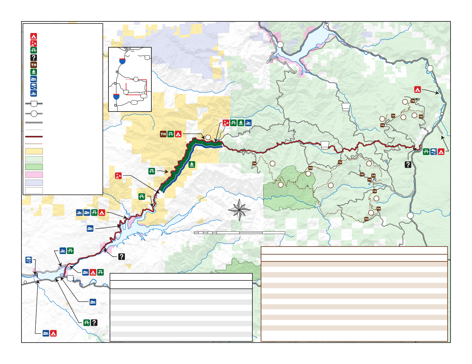
QUARTZVILLE
BACK COUNTRY
BYWAY
LEGEND
Camping
Group Camiping
Day Use or Picnic Area
Information Kiosk
Trailhead
Gold Panning
Boat Ramp
Fish Hatchery
Swimming
US Highway
State Highway
Improved Road
Other Road or Trail
Back Country Byway
Hiking Trail
BLM
US Forest Service
USFS Wilderness
Corps of Engineers
State
Private or Other
20
22
M00-00-21
2 0
42 6
Miles
S
E
N
W
Marion Forks (USFS)
(A)
= Accessible
$ 15 Faucet Vault 53 miles
Riverside (USFS) $ 37 Faucet Vault 57 miles
Yellowbottom (BLM) $ 22 Hand Pump Vault (A) 24 miles
Dogwood (BLM) Day Use Vault (A) 18 miles
Sunnyside (County) $ 165 Faucet Flush (A) 1 mile
Lewis Creek (County) $ Day Use Faucet Flush (A) 5 miles
Old Miner’s Meadow (BLM) $ 1 Group Site Vault 25 miles
Thistle Creek (County) Day Use Vault (A) 9 miles
Whitcomb (County) $ 92 Faucet Vault (A) 11 miles
Recreation Site Fee Campsites Water Toilets
Mileage from
US Hwy 20
Developed Recreational Facilities
Chimney Peak *3 12.3
Gordon Peak *5 4.6
Three Pyramids *9 2.1
Rhododendron 1.0
McQuade *2 5.2
Swamp Peak *4 6.1
South Pyramid Creek * 7.2
North Pyramid *8
1
7
3.4
Scar Mountain *
Bugaboo Ridge
Bachelor Mountain *
Bruno Meadows
Coffin Lookout *
6
13
12
11
10
8.9
2.1
7.2
3.4
8.9
Trail Name
Donaca Lake, Chimney Peak.
Middle Santiam Wilderness, Cascade peaks, old growth.
Three Pyramids, wildflowers.
Old-growth forest, rhododendrons.
Middle Santiam Wilderness, Chimney Peak, old-growth forest.
Middle Santiam Wilderness, Cascade peaks.
Middle Santiam River, old-growth forest.
Three Pryamids, wildflowers.
Cascade peaks, huckleberry picking.
Old-growth forest at lower elevations, wildflowers, Cascade peaks.
Former fire lookout, Cascade peaks, remnants of wildfire (snags).
Old-growth forest, rock gardens, wildflowers, wetland vegetation, Cascade peaks.
Cascade peaks, staffed fire lookout during fire season - closes at dusk.
Points of InterestNo. Length
M / D
M
E / M
M / D
M
M
M
M
M
E / M
E / D
E / M
M / D
Difficulty
Difficulty: E = Easy, M = Moderate, D = Difficult
* Trial Park Pass is required for these trails.
Hiking Opportunities in the Quartzville Area
Map
Area
PortlandPortland
Salem
Eugene
Albany
Albany
5
5
26
26
20
22
126
126
